Urban Geography
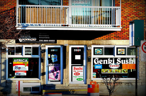
A sushi restaurant in Montreal illustrates the more diverse services and experiences available in the city than in many parts of rural Canada. Next door, a shop offers to wire money to Africa, helping immigrants stay connected to their place of origin and making the city a node in an international network.
photo from Flickr/caribb
Cities as Nodes in a Network [Link]
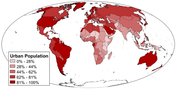
Figure 1: Urbanization rates. Map shows percent of a country's population that lives in an urban area.
data from CIA World Factbook
For most of the 200,000 years that Homo sapiens has existed, there were no such things as cities, as humans lived in small, usually nomadic, bands. The first cities emerged some 10,000 years ago, in places like Jericho in what is now the Palestinian territories and Çatal Höyük in what is now Turkey. At present, over half of the world's population (and growing) lives in cities, an unprecedented level of urbanization in human history (UN 2009). The structure and experience of urban landscapes is thus crucial to human geography today. We need to understand why people congregate in cities, and what happens when they do.
It is surprisingly difficult to define what exactly makes a city or where a given city's boundaries lie (Massey, Allen, and Pile 1999). City growth means municipal boundaries rarely correspond to the functional boundaries of a city -- for example, the city of Sydney proper is home to only 117,000 of the over 4 million people who live in the Sydney urban area. The density of settlement typically shades off gradually from the high rises of the central business district to the open spaces of the rural fringe, making it difficult to draw a clear boundary. Generally speaking, we can define cities by two key characteristics: they have a high density and intensity of human interaction, and they serve as major nodes in wider economic, cultural, or other networks. Cities are, then, places where people come together.
Cities are defined and made possible by their location within networks that extend beyond the city. A city is sustained by its economic, political, cultural, and environmental connections to other places.
Places can be organized into an urban hierarchy (Neal 2010). The urban hierarchy is a ranking of places on the basis of what services are available. Certain services require a large customer base, so they can only be found in larger cities at higher levels of the urban hierarchy. Consider, for example, someone living in a rural area of central Arizona. To get gas, eat at a restaurant, or use the post office, they may travel to the town of Eloy. Other services, however, are not available in Eloy. To go to the Motor Vehicle Division to get a driver's license, or to go to the hospital or many other medical facilities, our person would need to go to the nearby small city of Casa Grande. To take a flight to another part of the country, or to eat at a more uncommon type of restaurant (say, a Thai restaurant), our person would then have to travel to a large city like Phoenix. Each level of the urban hierarchy typically has fewer places in it. Thus, Casa Grande provides services not only for its own residents and those of Eloy, but also for other surrounding communities like Arizona City, Stanfield, Maricopa, and Eleven Mile Corner. And nearly every other place in Arizona would fall below Phoenix in the urban hierarchy.
At the top of the urban hierarchy lie global cities, sometimes also called world cities (Sassen 1991). A global city is a city that acts as a "control point" for global economic networks. This control may be directly economic, as when the city serves as a headquarters for major international corporations and corporate services like advertising agencies, banks, and law firms. The control may also be political, as in the case of the economic policies that emerge from both national (e.g. the US Congress) and international (e.g. the International Monetary Fund) institutions headquartered in Washington, DC. Or it may be cultural, as innovations in the world of fashion and design emanating from Milan shape the world economy.
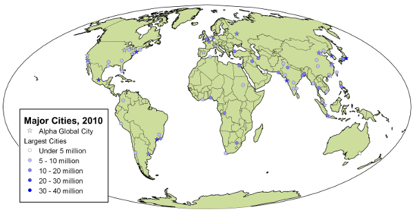
Figure 2: Major world cities. Note that global cities are not necessarily the largest cities -- Lagos and Karachi have far more people than Sydney and Frankfurt, but they play less of a central role in the organization of the world economy.
data from PopulationData.net and Global and World Cities Research Network
As shown in Figure 2, while most global cities are quite large, size alone is not the primary way global cities are defined. Many of the world's largest and most rapidly growing cities are located in the developing world. These cities may have extensive economic and cultural networks, such as the "Nollywood" film industry centered in Lagos, Nigeria. Nevertheless, they may lack the economic clout to attain global city power commensurate with their population size. The largest cities in the world are commonly referred to as megacities. Megacities can present particular challenges. The huge numbers of people in cities like Karachi or São Paulo can strain infrastructure such as water supply and transportation, leaving many of their people living in poor conditions. Stark inequalities of wealth and power can generate conflict, such as repeated attempts by city governments to bulldoze shantytowns built by the poor. Environmental conditions may also deteriorate, and many megacities have notoriously poor air quality.
City Location [Link]
Analysis of why cities are located where they are is a classic question in geography. As a general rule, the locations of cities are driven by a combination of the networks in which they are embedded, and the particular local conditions of their site. Cities grow up where local conditions are conducive to building the type of infrastructure that the larger network needs from its hub.
Perhaps the most common driver of city location is transport networks. Cities play crucial roles in the receipt, exchange, and shipment of goods. Chicago is a classic example of a transportation-focused city. Its location at the intersection of the Mississippi River transportation network with the Great Lakes transportation network made it an ideal entrepot for trade between the US's interior and east coast. Railways were subsequently built to run to Chicago, further cementing the city's centrality.
Other cities may generate networks around themselves, if their local conditions are compelling enough. Take the city of Mecca in Saudi Arabia. Mecca was origninally a minor trade hub. It grew to prominence after it was the scene of important events in the life of the Prophet Muhammad, making it the holiest city in Islam. As Islam spread and grew, networks of cultural significance and religious pilgrimmage remained anchored to Mecca, expanding its importance and size.
Finally, some cities may be built in a particular location as a deliberate attempt to construct a network of influence. This is most notable in the case of newly-built capital cities like Washington, DC, Canberra, Australia, and Brasilia, Brazil. The Brazilian government moved key administrative functions away from the existing large coastal cities to a remote location in the Amazon in order to more effectively project power over the country's large, sparsely-populated interior. It was hoped that moving the capital would encourage economic development of the Amazon by forcing networks of political power and influence to flow through the region.
The Internal Structure of Cities [Link]

Figure 3: Models of the internal structure of cities.
Cities are not homogeneous entities. The processes that create cities and the functions that go on in cities arrange their internal makeup in particular ways. A variety of models have been developed to explain the internal structure of cities (Harris and Ullman 1945). The most famous is the concentric ring model (Figure 3). The classic concentric ring model, called the Burgess model after its developer Ernest Burgess, was created to explain the structure of Chicago in the early 20th century, and later generalized to most contemporary developed world cities. The center of the city is the Central Business District (CBD), a zone where the most important business activities come together. Major government functions also usually locate in the CBD, as do institutions of "high culture" such as theaters and museums. The CBD is typically characterized by dense building of high-rises and skyscrapers, and a mix of wealthy professionals (lawyers, stockbrokers, etc) and poor service industry employees (maids, security guards, etc). Surrounding the CBD is an industrial zone, where manufacturing takes place. The next three zones are residential areas stratified by income. Poor and working-class people live near the factories where they work. Middle-class and wealthy residents can afford to seek out the larger living spaces and cleaner environments of the city's outskirts.
Cities in the developing world are often characterized by a concentric ring model that is partially the inverse of the Burgess model. While these cities also center on a CBD, it is the rich who live closest to it, seeking access to the power and wealth concentrated there. The outskirts of the city are home to extensive residential areas built up by poor people coming to the city from rural areas in search of jobs. These areas, often called favelas or pueblos jóvenes after their names in Latin America, are usually poorly integrated into the rest of the city. Nevertheless, they can develop their own vibrant street life and extensive informal (black market) economies.
Not every city has a single CBD. In some cases, such as the Dallas-Fort Worth metro area, two cities have simply expanded until they grew together. In developing countries that were once European colonies, it is common to have distinct "national" and "international" CBDs. The national CBD, often built on the old city center from the pre-colonial era, is the center of networks that focus on the nation, housing prominent national companies and national government institutions. The international CBD, built on the location where colonial rulers set up their operations, is home to headquarters and branch offices of multinational companies, connecting the city into global networks.
An alternative model of urban structure is the sector model. In the sector model, there is still a CBD, but industrial zones radiate out from it along transportation routes, forming zones that resemble wedges or pie slices. The remaining pie slices are various forms of residential settlement, with working-class people again living in the slices closest to the industrial areas.
A final well-known model is referred to as "keno capitalism" (Dear and Flusty 1998). In this model, based on Los Angeles, different districts are laid out in an essentially random grid, similar to a the board used in the gambling game keno. The premise of this model is that the internet and modern transportation systems have made location and distance largely irrelevant to the location of different sorts of activities within a city.
All of these models are huge generalizations. A variety of factors, ranging from the physical (water bodies and topography), to the structural (the location of transportation routes), to the historical (the legacy of how a city was built in response to past circumstances), to the political (barriers set up by municipal boundaries), to the cultural (enclaves and ghettoes for religious, ethnic, or racial groups) can disrupt the neat patterns suggested by the models. Nevertheless, each model captures and illustrates an aspect of the forces shaping the internal organization of a city.
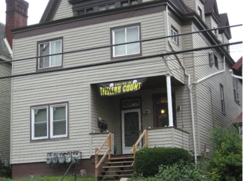
Figure 4: Steelers Country. Cities cultivate distinctive images to bind their citizens together and advertise themelves to outsiders. In this case, residents of Bellevue, Pennsylvania are drawn into a shared community with other residents of the Pittsburgh area through their passion for the Steelers professional football team.
photo from Flickr/acsumama
Cities experience an ongoing tension between integration and disintegration, unity and disunity. On a cultural level, various interest groups make great efforts to cultivate a sense of shared community and pride in a city. Cities may adopt particular identities as a deliberate marketing ploy, directed in this case not (just) at outsiders, but at the city's own residents to generate civic pride (Massey, Allen, and Pile 1999). Sometimes this is done through distinctive public architecture, such as Sydney's Opera House and Harbor Bridge, which give the city an easily-recognized image. Sports teams can also be an important agent of cultural unity, and cities invest millions of dollars to attract and keep major league teams. Consider, for example, the Pittsburgh Steelers football team (Figure 4). Devotion to the Steelers is pervasive, with both private businesses as well as government agencies (such as the Port Authority transit system) reaching out to customers by showing their Steelers pride. In this case the team name gives an added connection by echoing one of the most common images of the city, as a hub of steel production. But not everyone in Pittsburgh is a Steelers fan, and devotion to the team can become explosive when rooting for the team is pitted against other interests -- as, for example, when quarterback Ben Roethlisberger was accused of sexual assault (Rovell 2010).
The provision of public services provides an illustration of the tensions between unity and disunity on a practical level. The fact of so many people living in close proximity creates a need for various services, such as schools and public transit. A city may find, however, that the pool of people it is able to draw on to finance such services does not correspond with the pool of people making use of the services. For example, most of the well-off residents of the Washington, DC metro area live outside the bounds of the city, in places like Alexandria, VA and Bethesda, MD. These people commute into DC to work, making use of the city's transportation infrastructure, water and sewage, and police protection, among other things. But the city is unable to effectively tax these commuters (Weiss 2005), leaving such services to be paid for by the weaker tax base within the bounds of the District.
City Life [Link]

Figure 5: Sun River housing development, Chandler, AZ. Sun River, built in 2001-2004, offers acres of public parks and playgrounds in an attempt to create a sense of community in a self-contained corner of the sprawling Phoenix metro area.
photo from Flickr/Show Appeal Realty
The size of cities, the density of human activity that occurs there, the distinctive functions that go on only in cities, and the unique urban built environment all shape the tenor of city life. The urban way of life is distinctive in many respects from suburban and rural life.
One key problem for social life in the city is the management of the sheer volume of other people that one individual will encounter in day-to-day life (Massey, Allen, and Pile 1999). The urban dweller will cross paths with far more people than did their ancestors for most of human history, and furthermore these will be mostly people with whom one has no preexisting social connections -- true strangers. Cities typically develop customs designed to minimize unnecessary interaction and reduce the burden of sociality, customs which non-urbanites would find cold and unfriendly. Nevertheless, cities can also develop close communities by limiting the set of people one interacts with regularly, forming a close-knit neighborhood within the city.
Urban planning and design efforts have frequently worked to alter the built environment in order to cultivate these smaller and closer communities. Figure 5 shows an example from the Phoenix, Arizona metro area, where massive new development in the last few decades has been built mostly in the form of consciously self-contained residential communities, typically surrounded with a "privacy wall" to demarcate them from their neighbors. In practice, however, these deliberate communities have not necessarily created any real depth of social connectedness. A contrasting example is the fate of "The Block" in Redfern (part of Sydney), where Aboriginal residents attempted to redevelop an area to promote the formation of a strong community (Anderson 1993). The plan faced resistance because non-Aboriginal people in neighboring areas feared the formation of a distinct Aboriginal enclave, and wished to keep the area open to gentrification.
However, the relative anonymity of the city is its great appeal to many. Cities have long been seen as a refuge for people who would find themselves outcast or judged harshly by smaller communities where everyone knows everyone else's business. In a city one can maintain privacy, and find a subculture of similar individuals. The importance of cities as centers of LGBTQ life is a classic example, as people with marginalized sexualities migrated to cities to find each other and escape the homophobic conservatism of rural areas. This role of cities has become so well known, in fact, that there is a danger of ignoring the persistence of LGBTQ life in non-urban areas (Mortimer-Sandilands and Erickson 2010). LGBTQ people and their allies may then suggest that moving to the city is the only or natural path to liberation, while heterosexual rural residents can dismiss other sexualities as forms of decadence and deviance characteristic of far-away cities and absent from their own communities.
The City and its Hinterland [Link]
In order to survive, a city must draw on resources from a wide non-urban area, referred to as its hinterland. Modern transportation systems enable a city's hinterland to span the globe, as when New Yorkers eat fruit flown in from New Zealand during the winter. Nevertheless, the most important hinterland for any city is the local one extending out from the city's borders.
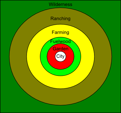
A classic model of how activity is organized in a city's hinterland is called the von Thünen model, after Johann Heinrich von Thünen, who developed it in the 1820s (Grotewold 1959). The von Thünen model (Figure 6) proposes that land use in a city's hinterland is organized into concentric rings, based on the balance between transport costs and profitability per acre. The central ring, closest to the city, is made up of vegetable gardening and dairying. These activities have high transport costs, as their products are heavy and spoil easily (especially in von Thünen's day before refrigeration). They also produce high profits per acre, meaning that they can afford to bid on the most desirable (and hence expensive) land close to the city. On the outskirts of the city's hinterland we get activities like ranching that have the opposite profile. Cattle are comparatively easy to transport (they would walk under their own power to the slaughterhouse in von Thünen's day) while the profit per acre is low because it takes a lot of pasture to raise a cow.
Since the 1800s, improvements to transportation -- first rail systems, and later the private automobile -- have allowed cities to expand. Along with simply growth in cities' sizes, we have also seen a rise in urban sprawl. Sprawl refers to the expansion of the area of a city faster than its population grows (Bruegmann 2005). Sprawling landscapes are characterized by extensive tracts of low-density development. By the 1970s, the developed world was witnessing a phenomenon known as the "population turnaround" (Burnley and Murphy 2002) -- for the first time, more people were moving out away from the central city than were moving into it.
A variety of factors drive sprawl. The symbolic landscapes of the city and the suburb are a powerful influence. If the city is percieved as disorderly, dirty, and crime-ridden, people who have the means to do so aim to escape to a more wholesome-seeming environment. This can set off a vicious spiral, as the departure of better-off residents undermines a city's tax base, leading to worse conditions (e.g. declining schools) that motivate even more people to leave (Pulido 2000). (Note that we have discussed this phenomenon before under the label of "white flight," since the people able to leave are disproportionately likely to be white.) Government policy also makes a difference. For ideological reasons, governments may wish to cultivate the ideal of the heterosexual nuclear family living in a detached house (Elder 2007). Heavy subsidies for building roads and other infrastructure make sprawl cheaper (Beimborn and Puentes 2003). Suburban laws limiting housing density and banning mixed-use development, originally passed to try to preserve a "rural" character to the area, force development to be sprawling (Lewyn 2007). Finally, in the United States there was a deliberate effort to spread out development during the Cold War to try to minimize the damage that could be done by a Soviet attack on a city (Kennedy 2006).

Figure 7: WUI around Denver, CO. "Intermix" is the portion of the WUI consisting of houses scattered within forested area, while "interface" is the portion of the WUI in which larger groups of houses abut forested areas.
data from University of Wisconsin SILVIS Lab
As cities in the developed world sprawl outward, the agricultural "buffer" between city and wilderness envisioned by Von Thünen is lost. Improvements to transportation and food preservation mean it is no longer necessary for a city to produce most of its provisions in its own hinterland. Philadelphians, for example, can enjoy fresh fruits and vegetables flown or trucked in from California and Florida. It them becomes more economical for agribusiness to concentrate its efforts on areas where there are large tracts of suitable land. Farmers in the immediate outskirts of many cities then face a dual financial pressure -- on one hand they are faced with competition from far-away growers that cuts into their profits, while on the other hand demand for new residential development drives up land prices. A cascade of farmers selling off to developers or abandoning farms to regrow into forests results (Furuseth and Lapping 1999).
The new landscape of residential settlement directly abutting wild lands is known as the wildland-urban interface or WUI (Figure 7) (Vince et al. 2005). The WUI differs from traditional rural settlements because its residents for the most part do not use the land for primary production activities like farming or logging. Instead, they commute (or telecommute) to work in the city, enjoying their wildland surroundings as an aesthetic amenity. The new arrivals to the WUI often clash with longtime residents over differences in cultural values and how growth of the area should be managed (Walker and Fortmann 2003). Moreover, new WUI residents may bring with them expectations about public services that were cultivated in the city. This too can create problems, as when a homeowner's expectation of fire protection runs up against the limited manpower of wildland firefighting agencies, and the homeowner's desire to be tucked away in a dense grove of trees conflicts with wildfire safety recommendations (Collins 2005).
Works Cited [Link]
Anderson, Kay J. 1993. Constructing geographies: "race," place and the making of Sydney's Aboriginal Redfern. In Constructions of Race, Place and Nation, ed. Peter Jackson and Jan Penrose, 81-99. London: University College London Press.
Beimborn, Edward, and Robert Puentes. 2003. Highways and transit: leveling the playing field in federal transportation policy. Washington: Brookings Institution.
Bruegmann, Robert. 2005. Sprawl: A Compact History. Chicago: University of Chicago Press.
Burnley, I. H., and Peter A. Murphy. 2002. Change, continuity or cycles: the population turnaround in New South Wales. Journal of Population Research 19 (2): 137-155.
Collins, Timothy W. 2005. Households, forests, and fire hazard vulnerability in the American west: a case study of a California community. Environmental Hazards 6: 23-37.
Dear, Michael and Steven Flusty. 1998. Postmodern urbanism. Annals of the Association of American Geographers 88: 50–72.
Elder, Catriona. 2007. Being Australian: Narratives of National Identity. Crows Nest NSW: Allen & Unwin.
Furuseth, Owen J., and Mark B. Lapping. 1999. Contested Countryside: The Rural Urban Fringe in North America. Brookfield, VT: Ashgate.
Grotewold, Andreas. 1959. Von Thunen in retrospect. Economic Geography 35 (4): 346-355.
Harris, Chauncy D. and Edward L. Ullman. 1945. The nature of cities. Annals of the American Academy of Political and Social Science 242: 7-17.
Kennedy, Roger G. 2006. Wildfire and Americans: How to Save Lives, Property, and Your Tax Dollars. New York: Hill and Wang.
Lewyn, Michael E. 2007. You can have it all: less sprawl and property rights too. Temple Law Review 80: 1093-1134.
Available at: http://works.bepress.com/lewyn/41Massey, Doreen B., John Allen, and Steve Pile, eds. 1999. City Worlds. London: Routledge.
Mortimer-Sandilands, Catriona, and Bruce Erickson, eds. 2010. Queer Ecologies: Sex, Nature, Politics, Desire. Bloomington, IN: Indiana University Press.
Neal, Zachary P. 2010. From central places to network bases: a transition in the U.S. urban hierarchy, 1900-2000. City & Community 10 (1): 49–75.
Pulido, Laura. 2000. Rethinking environmental racism: white privilege and urban development. Annals of the Association of American Geographers 90 (1): 12-40.
Rovell, Darren. 2010. Food maker drops Roethlisberger. CNBC.
Sassen, Saskia. 1991. The Global City: New York, London, Tokyo. Princeton: Princeton University Press.
United Nations, Department of Economic and Social Affairs. 2009. World Urbanization Prospects, the 2009 Revision. New York: United Nations.
Vince, Susan W., Mary L. Duryea, Edward A. Macie, and L. Annie Hermansen. 2005. Forests at the Wildland-Urban Interface: Conservation and Management. Boca Raton, FL: CRC Press.
Walker, Peter A., and Louise Fortmann. 2003. Whose landscape? a political ecology of the "exurban" Sierra. Cultural Geographies 10: 469-491.
Weiss, Eric M. 2005. D.C.'s bid to impose commuter tax denied. The Washington Post, November 5.